
We were recently brought in to help a landowner fix a failed wetland restoration project. Despite about $500,000 in planning and construction funding, the resulting series of linked basins were notably dry three years after construction; wetland plant cover was less than 1% over the 2.3 acres of basins (measured via 20 randomly located 3m x 3m plots).
These wetlands were designed to be flooded via a 2-ft diameter culvert placed in an adjacent creek. A hydrologic analysis was completed by a competent individual and the invert (bottom) of the culvert was set at about 6’ above the creek invert with the expectation that, on any rainfall events above the mean annual storm (MAS), the heightened flow in the creek would enter the culvert and then flood the basins.
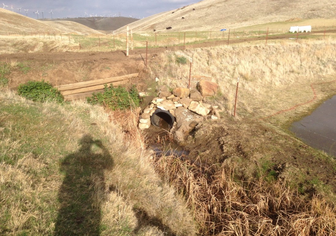
View of culvert feeding wetland basins (on other side of dirt road). Note proximity of creek and relatively minimal distance from creek bed to culvert invert (about 6”).
As we examined the creek, culvert and wetlands, we found that the culvert was partially blocked in its interior by a low (approximately 6’) dam of dirt and plant stems. In this region, with its dry summer and rainfall confined to the winter and early spring (assuming we have a normal year!), the first storms often bring with them a flood of organic debris that has been deposited in the creek channels over the summer and fall. It seemed that the initial storms in this system had deposited a small ridge of debris that was gradually heightened and “densified”. Looking at the hydrology predictions, the height of the dam inside the culvert was enough to ensure that only major storms would flood the downslope wetlands.
Watching the creek during the winter, the actual creek flood elevations did not match those predicted--the actual water levels were much lower. Examining the hydrologic predictions in more detail revealed that a relatively standard watershed runoff rate had been assumed, while this watershed was much less prone to surface runoff than predicted.
Even more troubling though, when we looked at the monitoring logs, we found that the consulting team that had done the restoration planning and which was responsible for the monitoring only visited the site once or twice each winter. In fairness, I should note that the original consulting firm had been subsumed within a larger firm and the site is not easy to get to in the winter—4WD is definitely required. But, as was clear from the logs, no one had visited the site during a major rainfall.
The take home lessons are, unfortunately, very clear.
Small culverts are not a good choice as the sole means of water for a wetland: they are easily blocked. We do not have beavers in this region but I’ve seen numerous cases of beavers blocking culverts of this size as well. A later blog will address large culverts. In any case, consider open connections to water sources whenever practicable.
Err on the wet side in your hydrologic predictions. Better yet, actually observe the system in question over a winter (assuming you have that luxury).
Monitor your restoration sites during rainfall events. We try to be there the first winter for any event that exceeds the MAS. For wetlands especially, the MAS is often critical in establishing wetland boundaries and, accordingly, for defining project success.